

Advanced Earth Intelligence for Environmental Compliance
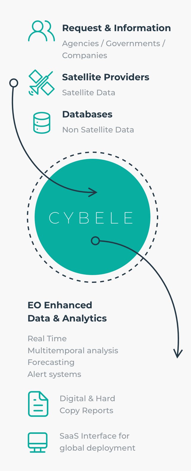
CYBELE develops state-of-the-art Earth Observation and AI solutions that help organizations detect environmental change, assess risk and monitor the impact of human and industrial activities. From algorithms and prototypes to operational monitoring services, we turn satellite data into reliable intelligence for ESIA, ESG, environmental compliance, audits and risk analysis.
Expertise
We combine Earth Observation and AI to advance environmental monitoring and compliance.
CYBELE develops end-to-end satellite data processing and GeoAI solutions from algorithm design, model training, and validation to prototypes, automated processing chains, and operational environmental monitoring services.
Services
Risk and Impact Assessment
Analyse different types of environmental risks related to your activities

Alert Systems
Detect suspicion of non compliant activities and receive an alert


Multi-Temporal Monitoring
Access near real time information on environmental status and compare them with historical data


Damage Evaluation
Evaluate the impact of industrial activities on the environment and find the cost
Solutions
Our products and services empower government agencies, businesses, financial and legal firms, and civil society organisations to detect risks, monitor change, and make informed decisions across the forestry, mining, construction, and maritime sectors.
Sectors
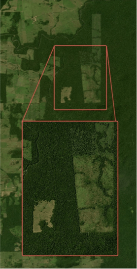
Forestry & Habitats
EIA and ESG assessments
Biodiversity reporting
Illegal logging detection
Habitat monitoring
Maritime Monitoring
Vessel detection and tracking
Maritime infrastructure monitoring
Illegal activity detection
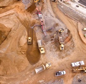
Mining & Waste
EIA and ESG assessments
Sustainability reporting
Illegal mining detection
Encroachment monitoring
Integrate Earth Observation and AI into your environmental processes
CYBELE combines satellite data processing, GeoAI, and multi-source data fusion to deliver operational environmental intelligence. We develop cloud-based geospatial infrastructures, APIs, and interactive WebGIS platforms using open standards and OGC-compliant services. This enables seamless integration with existing GIS platforms, environmental compliance workflows, reporting tools, and decision-support systems.
Our solutions support Environmental Impact Assessments (EIAs), biodiversity management plans, regulatory compliance, REDD+ projects, environmental audits, ESG reporting, due diligence, risk assessments, and long-term environmental monitoring.
Adapting our products to your needs
We take particular care to understand your needs and requirements. After assessment, we guide you to our most relevant products and services or develop customized solutions for you.
Step 1
Presentation of CybELE products and services
Earth Observation, Environmental Compliance, Demonstration of Reports & Digital Services
Step 2
Assessment of your needs & requirements as end users
Work Process Analysis, Requirements Definition & Budgeting
Step 3
Providing you with the appropriate solution.
Are you looking for an independent and global solution to monitor several sites simultaneously?
Web Platform & Digital tools
Our CybELE platform license to access and use your EO analytical tools at any moment on the cloud.
Do you need EO support and periodic satellite monitoring with expertise for data analysis?
Digital Reports
We provide ready-to-use reports that include high-resolution enhanced satellite images, data analytics, and certification.
Do you have specific needs and would like to develop a tailored solution?
EO Development Services
We develop on-demand EO and webGIS tools to integrate satellite data into your existing systems.
Area Covered by
Cybele Monitoring
km2
Number of Environmental
Risk Cases Detected
Companies' savings due to environmental compliance
Case Studies
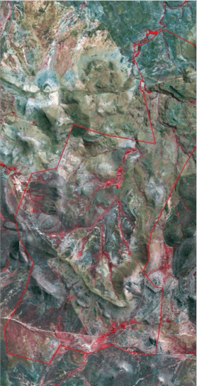
Louvakou, Republic of the Congo
Compliance Analysis of Awarded Forest Concessions with Local and National Regulations
Development of a Web-based Geographic Information System (GIS) combining field data and satellite data to monitor yearly exploitation of forestry concessions.
Sector: Forestry
User: Government / NGO
Uru Eu Wau Wau
Monitoring Supply Chain Compliance with Forestry Regulations
Geo-spatial analysis and reporting to assess the pressure of agriculture and cattle industries in protected areas based on satellite data.
Sector: Forestry
User: Law enforcement / NGO
Bergplaas Nature Reserve
Geo-spatial Impact Assessment of Controlled Fires
Remote analysis and reporting on the use of fire as a management tool in a natural reserve.
Sector: Forestry
User: Natural reserve
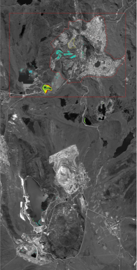
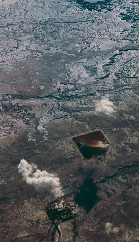
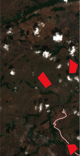
Peru, Cerro de Pasco
Earth Observation-Based Monitoring of Mining Infrastructure for Financial Stakeholders
Geo-spatial analysis of the impact of mine tailings on the environment and surrounding water bodies, and compliance with waste storage regulations.
Sector: Mining
User: Law enforcement, Pension Funds
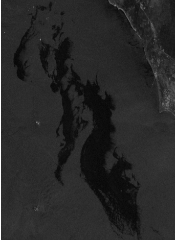
Persian Sea
Oil Spill Detection for Law Enforcement Authorities
Geo-spatial analysis and reporting of oil spill releases at sea that are non-compliant with Maritime Law and assessment of remedial costs.
Sector: Maritime
User: Maritime Law Enforcement Agency
Case Studies
CybELE is mandated by law firms, law enforcement agencies, companies and foundations to contribute to projects related to land, maritime, and soil monitoring.

CybELE is mandated by law firms, law enforcement agencies, companies and foundations to contribute to projects related to land, maritime, and soil monitoring.
Standards & Certification
Cybele relies on legal expertise to ensure the highest level of compliance with standards related to Earth Observation. Regular checks are carried out to verify alignment with the relevant legislation and best practices related to data reliability and quality, privacy rights as well as the security of our confidential data.
Cybele Awards
2018
Copernicus B2B Overall Winner
2018
Copernicus B2B Challenge
2019
Airbus Global Earth Observation Final Challenge (2nd prize)
2019
Startup Trophee - Chambre de Commerce et industrie Franco-Portugaise
Would you like to build your own system for environmental satellite monitoring?
Send us a request to detect, track, monitor or assess any type of non-compliance with environmental legislation or to assess potential environmental damage.
Explain to us your project and skills!
Are you an Earth Observation expert or web developer interested in supporting environmental compliance monitoring?